
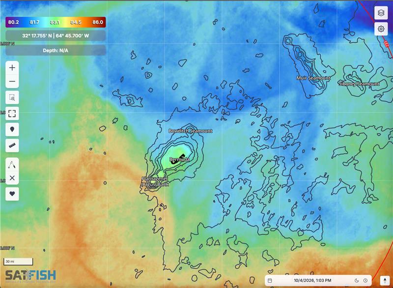
SatFish’s Bermuda fishing map gives anglers a detailed view of the deep Atlantic waters surrounding the island, where dramatic bottom structure and open-ocean currents create excellent opportunities for offshore fishing. Bermuda sits atop a large volcanic seamount that drops steeply into water more than 4,000 meters deep, with Challenger Bank and Plantagenet Bank, commonly called Argus Bank, providing additional offshore structure. These banks and their edges are important fishing areas for pelagic species including tuna, wahoo, and blue marlin. Use SatFish sea surface temperature (SST), chlorophyll, and altimetry/current charts to identify temperature changes, productive water-color edges, and moving water that can help concentrate bait when searching for yellowfin tuna, blackfin tuna, wahoo, mahi, blue marlin, white marlin, and other Bermuda gamefish.
Bermuda fishing is heavily influenced by open-ocean water movement, making current and satellite imagery especially useful when deciding where to start the day. Instead of simply looking for the warmest water, watch for SST breaks, current boundaries, eddies, and chlorophyll changes around the Bermuda Platform and offshore banks. The edges where shallow banks fall rapidly into deep water are particularly important features, with Bermuda government marine research identifying the perimeter of the Bermuda seamount as productive habitat for pelagic species such as tuna and wahoo. When clouds interfere with a clean satellite pass, SatFish Cloud-Free SST and 1-day and 3-day SST composites help reveal the larger temperature pattern so you can continue tracking productive offshore water.
SatFish’s detailed Bermuda bathymetry maps add an important dimension to trip planning by showing the sharp depth changes surrounding the Bermuda Platform, Challenger Bank, Argus Bank, and other offshore structures. Challenger and Argus rise to roughly 50 to 60 meters below the surface before their slopes descend into much deeper Atlantic water, creating significant structure for bait and predators. Compare these depth contours with SST, chlorophyll, and currents to see where favorable water is interacting with bank edges and drop-offs. Whether you’re trolling for wahoo, looking for yellowfin tuna around the banks, chasing blue marlin in deep water, or exploring structure for snapper and grouper, the SatFish Bermuda fishing chart gives you the satellite data, bathymetry, and 5-day wind forecast to build a better plan before heading offshore.
Frequently Asked Questions
What does the SatFish Bermuda fishing map help me find?
The Bermuda fishing map helps you identify SST breaks, chlorophyll edges, currents, and bottom structure around the island and surrounding offshore banks. These features can help narrow down productive areas when targeting tuna, wahoo, mahi, marlin, and other pelagic gamefish.
Where should I look for offshore fish around Bermuda?
The edges of the Bermuda Platform and offshore banks are good areas to study because relatively shallow water drops quickly into the deep Atlantic. Challenger and Argus Banks are recognized offshore fishing areas where pelagic species, bait, and larger predators occur. Use SatFish to see how current, temperature, and water color are setting up around these features rather than fishing structure alone.
Why are Challenger Bank and Argus Bank important for Bermuda fishing?
Challenger Bank and Plantagenet, or Argus, Bank are offshore banks that rise to roughly 50 to 60 meters below the surface. Their shallow tops and steep surrounding slopes create major changes in underwater terrain, and Bermuda marine research identifies these banks as habitat for baitfish and pelagic predators including tuna, wahoo, and blue marlin.
How can SST help with tuna and wahoo fishing in Bermuda?
Use SST to look for changes in temperature rather than chasing one exact number. Defined breaks, pockets, and edges can show where different bodies of water are interacting. Check those features against currents and chlorophyll to see which areas have the strongest combination of conditions.
How should I use chlorophyll around Bermuda?
Chlorophyll helps distinguish changes in water color and productivity. Look for defined boundaries between different water masses, then compare those edges with SST and current data. When several features overlap near a bank edge or major depth change, you have a more focused area to investigate.
What should I use when clouds block the latest SST image?
Switch to SatFish Cloud-Free SST and the 1-day and 3-day SST composites. These layers help you see the broader temperature pattern when cloud cover prevents a complete look at the ocean from a single satellite pass.
What species can I target offshore in Bermuda?
Bermuda’s offshore waters support wahoo, yellowfin and other tunas, swordfish, marlin and additional pelagic species. Local fishing regulations include species-specific minimum sizes, bag limits, and protected species, so anglers should always check current Bermuda regulations before fishing.