SatFish provides many features that help all types of anglers up their game. Whether you are a novice angler just starting your journey into offshore fishing or a seasoned tournament angler, SatFish provides the tools to take your game one step further and help you catch more fish.
Videos on this page:
- Complete Interface Tutorial
- Base Layers, Contours, & Buoy Data
- Reading SST & Chlorophyll Maps
- Using SST & Chlorophyll to Find Offshore Hotspots
- Advanced Tips for Offshore Fishing
- Building an Offshore Gameplan
- How to Use SatFish When Skies are Cloudy
- Catch More Fish in the Florida Keys by Capt. Ryan Van Fleet
- Find More Tuna Using Satellite Maps [Bluefin + Albacore]
- How To Find Bluefin Tuna Offshore Using Satellite Maps (Complete Breakdown) | D&D Fishing
- How to Use SatFish to Find Swordfish and Mahi Mahi | Marathon Sportfishing
- Swordfish Pre-trip Planning | Captain Matt of Marathon Sportfishing
- Florida Keys Patch Reef Fishing | How To Find Productive Spots with SatFish
Complete Interface Tutorial
In this step-by-step tutorial, Captain Ali Hussainy from Local Knowledge walks you through all the essential tools and features of the SatFish mapping interface, available on both desktop and mobile apps.
Base Layers, Contours, & Buoy Data
In this easy-to-follow tutorial, you’ll learn how to utilize detailed base maps, bathymetric contours, labeled fishing hotspots, latitude-longitude grids, and real-time National Weather Service buoy data directly integrated into SatFish. Whether you’re fishing your local waters or exploring new offshore regions, Captain Ali Hussainy from Local Knowledge shows you exactly how to customize SatFish maps to identify productive fishing zones, underwater structures, depth changes, and current sea conditions.
Reading SST & Chlorophyll Maps
In this video, Capt. Ali Hussainy demonstrates how SatFish’s ultra-high-resolution sea surface temperature (SST) and chlorophyll maps help pinpoint productive fishing areas before you even leave the dock. Learn how interpreting these detailed, fisherman-driven maps can save you valuable time and fuel while dramatically increasing your chances of locating fish, birds, dolphins, and other marine life offshore.
Using SST & Chlorophyll to Find Offshore Hotspots
In this video, we walk through how to use Satfish to plan your offshore fishing trips more effectively. Starting from the Satfish dashboard, you’ll learn how to navigate regional maps—like the Baja, Los Cabos, and East Cape zones—and use satellite imagery to track sea surface temperatures (SST) and chlorophyll levels.
Advanced Tips for Offshore Fishing
What you’ll learn in this video:
- How to interpret High-Definition SST & Chlorophyll maps
- The benefits of 1-day and 3-day composite maps
- Understanding cloud-free SST maps during low-visibility conditions
- Identifying productive fishing edges, currents, and clean water zones
- Practical tips for logging data and improving future offshore trips
SatFish Will Help You Build Your Best Gameplan
In this video, Capt. Ali Hussainy of Local Knowledge explains why SatFish is such a valuable tool and how to use its features like Sea Surface Temperature Charts and Chlorophyll Charts to identify areas of water that may be holding fish.
Even when the Skies are Gray, SatFish can Save the Day
Don’t let gray skies get you down. In this video, Capt. Ali explains the answer to one of our frequently asked questions, “How come there are blank areas on the charts?” In short, the answer is clouds. In explaining the answer to the question, Ali also demonstrates how to use other charts that SatFish offers to overcome this obstacle and still find the fish. Charts like our Composite SST/Chloro as well as our Cloud-Free SST can be very useful when properly understood.
Find More Fish
Capt. Ryan Van Fleet of Good Karma Sportfishing is one of our SatFish ambassadors, and we are proud to be working with him! Capt. Ryan avidly fishes the Florida Keys, and in this video he shares how he uses tools that SatFish provides to successfully target various species of fish in the area.
Find More Tuna Using Satellite Maps [Bluefin + Albacore]
Ever wonder how offshore anglers consistently find tuna before leaving the dock?
In this video, we break down exactly how we use temperature maps and chlorophyll maps to locate bluefin and albacore tuna. We go over why these breaks are the key to finding bait and life offshore. We’ll walk through real world examples from past trips, show you how we read SatFish maps, and explain what we look for: temperature breaks, chlorophyll edges, and current lines that stack up bait. Whether you’re new to offshore fishing or looking to fine-tune your strategy, this guide will help you plan better trips, find fish faster, and avoid dead water.
How To Find Bluefin Tuna Offshore Using Satellite Maps (Complete Breakdown) | D&D Fishing
Want to know how to use the SatFish app to locate bluefin tuna and albacore offshore in Northern California?
In this video, we cover most of the SatFish layers, including SST, Chlorophyll, True Color, SSH, and Currents. Later in the video, we do a real-time breakdown of current Northern California maps and show you exactly where we’d be targeting fish right now, including a second region breakdown and a live proof of concept from a recent Hawaii trip where we used SatFish to put us on tuna. The logic and planning used in this video can be applied all over the world when targeting pelagic fish.
How to Use SatFish to Find Swordfish and Mahi Mahi | Marathon Sportfishing
At the end of this video, Captain Matt breaks down how he uses SatFish to target Swordfish and Mahi Mahi. He dives into what layers he uses, what he looks for in these layers, and where he would go if he was planning a fishing trip the next day. Captain Matt uses both the SST and Current layers to give himself the best idea of what is going on offshore. He shows what conditions he looks for when sword fishing, as well as where he believes some Mahi Mahi might be based on the latest offshore conditions.
Swordfish Pre-trip Planning | Captain Matt of Marathon Sportfishing
Captain Matt explains that no matter what type of fishing he is doing, he always checks in with SatFish to stay up to date with the latest offshore conditions.
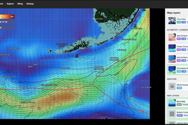
In this breakdown, Captain Matt examines an unusual eddy off the coast of the Florida Keys as he creates a game plan for swordfish fishing. The SatFish “Current” layer shows him the best place to go deep-drop for swordfish. Not only does he know where to go the next day, but he also saves fuel when planning with SatFish.
Florida Keys Patch Reef Fishing | How To Find Productive Spots with SatFish
In this video, Captain Matt with Marathon Sportfishing breaks down exactly how he chooses where to fish the patch reefs using SatFish. He’ll show you what he looks for, how he decides whether to fish inside or outside of Hawk Channel, and why current movement makes all the difference.
The patch reefs here stretch roughly 4.5 miles offshore, with depth changes from 10 feet down to 40 feet, back up to 20 feet, and then dropping off deeper. Knowing where to set up can be the difference between a slow day and steady action. Nothing huge this trip, but a great day on the water and a solid breakdown of how to approach patch reef fishing when offshore conditions aren’t ideal.